


You are using an out of date browser. It may not display this or other websites correctly.
You should upgrade or use an alternative browser.
You should upgrade or use an alternative browser.
Crimson Arrows
Well-Known Member
Great post and I have tried to use terrain since 1998. In fact, I have hunted sign very little and have had good success. However, the past two years have been frustrating as I thought I had found even BETTER spots but I have not seen the deer movement I thought I would. Still, its weird, but I feel like i need to go back and keep trying as the DEER MUST go through certain spots such as a funnel formed as a ditch runs uphill and stop say 50 yards from a field edge. Or as you pointed out, having brush, creeks, or drop offs behind you that funnels them through. These I thought would be perfect spots but only saw one 130" 10 walk by this year that was very young in these stand sights. I remember reading about this from Bill Winke in college and it has worked great but this year I struck out. Nothing is hunting is a sure thing though but still like terrain over sign.
kurtish
Member
First off I have to say Great idea, this should be a cool way to stimulate some interesting conversation and help us all become better hunters.
While looking at you're aerial photo I noticed that the heavy creek crossings are both located after a sharp bend in the river and when I was thinking about my favorite stretches of trout stream it hit me. The corners of rivers and streams will typically have your deep water hole that is heavy in current and a short ways after the corner the water slows and dumps the sediment from the deep hole. Thus creating a shallower section where deer will be able to cross easier. It may not hold true in every occasion but I would think that if you were coming into a river bottom property blind you could pull aerial photo's and come up with some reasonably close ideas as to where the deer will cross the river without ever setting foot on the property.
While looking at you're aerial photo I noticed that the heavy creek crossings are both located after a sharp bend in the river and when I was thinking about my favorite stretches of trout stream it hit me. The corners of rivers and streams will typically have your deep water hole that is heavy in current and a short ways after the corner the water slows and dumps the sediment from the deep hole. Thus creating a shallower section where deer will be able to cross easier. It may not hold true in every occasion but I would think that if you were coming into a river bottom property blind you could pull aerial photo's and come up with some reasonably close ideas as to where the deer will cross the river without ever setting foot on the property.
jjohnson
Well-Known Member
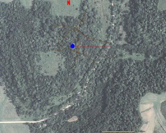
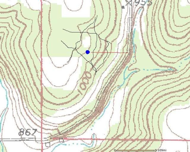
Here's one of my spots. To my NW is a very thick bedding area (which also acts as a funnel from big valley to west and big valley to east), To my SW is small crp field, and to my East is a gravel road. I access the stand (blue dot) from the gravel road. I've placed the stand right at the top of the ridge and with a west wind in the morning my scent is gone.
It's a neat little spot because I'm on an inside corner of the crp field. Also just to my north and just to my south are two small ravines. Really they're not even ravines but on the topo map you can see the small breaks in the ridge lines. This just makes the slope of the ridge a little more gradual. Like a magnet deer will travel up and down these two low spots.
Blue dot is stand site
red line is access route
brown lines are main deer trails
Grasshopper
New Member
Excellent thread and post /forum/images/%%GRAEMLIN_URL%%/cool.gif
Just from the aerial/topo, you have this stand site dialed. And the approach is perfect for a morning sit. Those uphill hikes are a bear, but since I started this practice my success on a.m. sits has soared.
Keep up the good work!
Just from the aerial/topo, you have this stand site dialed. And the approach is perfect for a morning sit. Those uphill hikes are a bear, but since I started this practice my success on a.m. sits has soared.
Keep up the good work!
deerhunter93
Well-Known Member
This is a great thread! I have one question though... How are you guys able to write on the arial photos? For example showing where stand locations are with a red dot?
jjohnson
Well-Known Member
<div class="ubbcode-block"><div class="ubbcode-header">Originally Posted By: deerhunter93</div><div class="ubbcode-body">This is a great thread! I have one question though... How are you guys able to write on the arial photos? For example showing where stand locations are with a red dot? </div></div>
I'm sure there's different ways maybe even easier but I just saved under my pics. Then open it up in paint and you can doodle on it.
I'm sure there's different ways maybe even easier but I just saved under my pics. Then open it up in paint and you can doodle on it.
deerhunter93
Well-Known Member
Thanks!
bowman
Super Moderator
Excellent examples guys! JJohnson, thanks for adding the topo! The terrain features really stand out on a topo. NWBuck, I have permission on both the East and Northeast. The Northeast is very hard to approach because other than the small corner of cover, the rest is open field and the farmer farms fence row to fence row making scouting or hunting prior to the crops coming out almost impossible. The property just to the east has a great funnel on the southeast corner but there is not the connecting cover there to bring the amount of deer through that the Northwest funnel has.
Thanks again for the examples everyone! Keep them coming!
Thanks again for the examples everyone! Keep them coming!
bowman
Super Moderator
I received this photo from an Iowawhitetail member who wanted some help in picking stand sites from his hunting property. The photo below shows what I marked for him. If you see something that I didn't see feel free to add your comments. He would appreciate any assistance. This place has some great pinch points!

#1 looks like a great funnel that can be hunted with a southeast wind
#2 looks like a great funnel that can be hunted with a northwest wind
#3 is worth looking at but there might not be suitable trees. Three travel routes appear to come together there.
#4 would be good for east / west deer movement or for deer wanting to head northeast to the fields. I would hug one of the field corners and have my wind blow into the field.
#5 looks like another good funnel that you might be able to make an easy fence crossing within 20 yards of a good tree!") A north east wind would be best but could get by with a south / southwest
A north east wind would be best but could get by with a south / southwest
#6 it appears that the 2 points of cover are close to each other in this area and it could be a good place for the deer to cross. Southeast wind?
#7 could be hunted with a northwest wind and capitalize on deer wanting to travel to or from the timber patch to the south (not visible in this view)
#8 looks like the closest point that the south and the north timbers come to each other. Might need to look further east if that is a waterway connecting the two over there.
#9 is a great pinch point! Southwest or Northeast wind depending on which side the stand is set.
*Another spot that could be good is between #5 and #2 just to the south at the north end of that little field.
Alright guys, give him your thoughts??
#1 looks like a great funnel that can be hunted with a southeast wind
#2 looks like a great funnel that can be hunted with a northwest wind
#3 is worth looking at but there might not be suitable trees. Three travel routes appear to come together there.
#4 would be good for east / west deer movement or for deer wanting to head northeast to the fields. I would hug one of the field corners and have my wind blow into the field.
#5 looks like another good funnel that you might be able to make an easy fence crossing within 20 yards of a good tree!
A north east wind would be best but could get by with a south / southwest#6 it appears that the 2 points of cover are close to each other in this area and it could be a good place for the deer to cross. Southeast wind?
#7 could be hunted with a northwest wind and capitalize on deer wanting to travel to or from the timber patch to the south (not visible in this view)
#8 looks like the closest point that the south and the north timbers come to each other. Might need to look further east if that is a waterway connecting the two over there.
#9 is a great pinch point! Southwest or Northeast wind depending on which side the stand is set.
*Another spot that could be good is between #5 and #2 just to the south at the north end of that little field.
Alright guys, give him your thoughts??
bowman
Super Moderator
South of #7 looks good Nug!
Hey guys, I have recieved some PM's from guys that are hesitant to post the pics of their hunting spots under their names for fear of stand theft, tresspassing, etc. If you zoom in to exclude any roads and send me the photo's I'd be happy to post them for you so your identity is unknown, just as I did the last one.
Thanks again for participating!
bowman
Super Moderator
I recieved the following photos from an iowawhitetail member who would like your assistance. If you have some time, take a look and point out stand sites on the three photos. Thanks again for your help, I know he will appreciate it!
The 1st propert is bordered in yellow. The area around the pond is CRP and the area around the CRP (the greener area) is alfafa. The Northwest fields (within the property)are crops as well as the neighboring property to the west.

The 2nd property has some great features. Again it is bordered in yellow. Other than the area to the west marked as "Crop Fields" all other open areas within the property are CRP.

The last photo is pretty clearly marked. The small green circle to the west of the east crop fields is a food plot currently planted in clover.

I'll leave this one for the experts (that's you!) Where would you hunt if this were your property?
The 1st propert is bordered in yellow. The area around the pond is CRP and the area around the CRP (the greener area) is alfafa. The Northwest fields (within the property)are crops as well as the neighboring property to the west.
The 2nd property has some great features. Again it is bordered in yellow. Other than the area to the west marked as "Crop Fields" all other open areas within the property are CRP.
The last photo is pretty clearly marked. The small green circle to the west of the east crop fields is a food plot currently planted in clover.
I'll leave this one for the experts (that's you!) Where would you hunt if this were your property?
BuckStop
New Member
I'll play along. All suggestion are of course wind dependant, and with mid November in mind.
Picture #1
Spot 1
I would hunt (morning for sure and maybe evening too) just south of dam in the timber and somewhere between the dam and the south property line depending on where I found the trail(s). Morning hunt can be approached well hidden from the north side of the lake and behind the dam.
Spot 2
NW corner of the timber with the finger of timber close by to the north. I would have to check out the area with loner trees in small CRP just north of the timber for possibilities too.
Picture #2
Spot 1
By far the best looking spot out of the three pics is the NW corner funnel. This would be a primo pack a lunch and pee bottle and stay all day spot. Access is good up western edge of timber/property line.
Spot 2
Second best spot in the three pics is at the point of the timber located in the eastern most area of the propery and right before the start of the very thin line of trees. Should be a magnet for travelling bucks moving between bedding areas.
Picture #3
I'd have to hunt between the very little crop field/clover food plot and the property line.
bowman
Super Moderator
Great work Buckstop! All of the spots that you pointed out would be well worth looking into. Photo #1 and Photo # 3 don't have the distict terrain features that Photo #2 has. Those spots might require a walk to get a better feel.
I will give this a little longer so that some of our "experts" can throw out their comments before I mark up the photos with my "non-expert" opinions! /forum/images/%%GRAEMLIN_URL%%/grin.gif
We would welcome some more photos and topographical map examples. I learn a ton when I see other peoples properties / stand locations and an explanation of why the spot works.
Thanks again!
bowman
Super Moderator
If I were going to scout these properties to hunt next fall, I would look first at the areas that I marked with yellow dots.


These are the places that I would look initially based on what I can see of the terrain features visible in the aerial photos. It would be bennificial to get a topo of the properties.
I hope this is helpful to the member that sent me the photos.
These are the places that I would look initially based on what I can see of the terrain features visible in the aerial photos. It would be bennificial to get a topo of the properties.
I hope this is helpful to the member that sent me the photos.